At the end of part 2 of our round-the-world tour, we had just landed on a tiny airstrip upon making a first landfall at the western tip of Jamaica, arriving there from Cuba by way of the Cayman Islands.
If landing the larger 6-seater airplane, the Beechcraft Baron 58, on that tiny airstrip wasn't a workout enough for my still-limited landing skills, later landing on an aircraft carrier, while in transit to Haiti, certainly stretched my abilities! Fortunately, I had fortified myself with a training video on handling sideslips, i.e. fine
alignment with the landing strip. That has been my Achilles' heel so far: ending up a
little diagonal and/or offset, just as I'm about to touch down... Getting better, though :)
North-West of Jamaica : Montego Bay
In Jamaica, I've been fascinated by two gorgeous bays: the first one is Montego Bay, close to my original landfall on the island.
Here are two views of Montego Bay in Google Earth, approaching the airport from opposite directions. In the video below the photos, you can see those two same views, as I first approach the airport from the west and then overshoot and turn around.
Google Earth view of my initial approach, from the west (Montego Bay in the foreground)
Close-up view of the airport from the opposite direction (Montego Bay is now in the background)
Jamaica is much smaller than our earlier major island, Cuba. It's only about 230 Km (140 miles) by 75 Km (45 miles); so, it's easily crossed, with both north and south coasts at times visible during my flight.
Crossing Jamaica in its long dimension, towards the capital of Kingston
Approaching the bay by Kingston
Taking a first peek at the hills just past Kingston
As if the two major bays weren't impressive enough, Jamaica had one last departing gift: the Blue Mountains of its eastern side. With peaks reaching 2,260 m (7,400 ft), I had to crank up some altitude gain without much dilly-dallying! Especially impressive elevation for such a a relatively small island!
The Blue Hills rising in the background. Kingston is on the left, by the bay. The eastern end of the island visible in top/right
The Blue Mountains. The altitude gauge is showing 5,700 ft; must climb: peaks reach 7,400 ft, (2,260 m)!
Landing on an Aircraft Carrier between Jamaica and Haiti
As luck had it, early on in the 190 Km (120 mile) water stretch between Jamaica and the nearby Haiti, the aeronautic chart of the simulator showed an aircraft carrier.
I had tried a landing on an aircraft carrier when I first started using the simulator, with disastrous results, cough, but after so much more practice, I actually managed this time. That's what simulators are for, aren't they? ;)
A tense moment prior to my first successful landing on an aircraft carrier
Whew, managed to land! (near the center, on the side of the runway)
While on the subject of aircraft carriers, I recommend the earlier episodes of a remarkable 10-part PBS documentary that I watched, Carrier (2005) :
Here's my review of it:
Extended documentary about life on a huge aircraft carrier, for the duration of a 6-month deployment, a couple of years into the Iraq war.
The earlier episodes are interesting and engaging, but the long series (10 episodes) eventually runs out of steam, and becomes fairly trite and tedious by the end.
The documentary isn't about the military hardware and firepower; nonetheless, especially when the soap-opera aspect rears its head (increasingly so in later episodes), it would've been interesting to hear a little more about the ship and a shade less about the people.
Too much focus on low-rank sailors and the high-school-like quality that their world often possesses.
The reality-style feels cheesy at times, especially in the last two episodes.
While the documentary generally shines a favorable light on the military, it doesn't have a pro-war bias, and in fact several interviewees come out against the Iraq war or express major reservations about it.
Haiti Landfall, and the lush "Pic Macaya" National Park
In the middle of nowhere, 55 Km (35 miles) prior to reaching Haiti, I pass by the tiny Navassa island, about 3 Km (2 miles) across:
Haiti landfall, arriving at the western end of the island of Hispaniola
The same bay (Baie des Irois), as seen in Google Earth
Shortly upon arriving at the western end of Hispaniola, the island shared between Haiti and the Dominican Republic, I was awed by the lush beauty of the Pic Macaya National Park; notice the sharp climb as I get nervous about getting too close to the mountains! Elevations in the rugged park reach 2,350 meters (7,700 feet)
Traversing the lush "Pic Macaya" National Park; notice the 5,100 feet (1,550 m) in the altimeter gauge
Topographic maps of Haiti: map 1map 2 (notice the tall "Macaya Peak" near the western end)
Upon having crossed over to the north coast, about to land by the town of Jeremie. Notice the landing strip near the center
AIRPORTS: Negril (little air strip), Jamaica, (MKNG) ; Montego Bay, Jamaica, Sangster Airport, (MKJS) ; Kingston, Jamaica, Norman Manley Airport (MKJP) ; aircraft carrier in Caribbean Sea between Jamaica and Haiti ; Jeremie airport, Haiti (MTJE)
Nice work adding all the interesting links about the things that you encounter. I personally enjoy sampling the local foods in the places I visit. Maybe you could work in a little of that into your blog as well!
Thanks for the compliments and for your suggestion. I have been reflecting on your idea about covering the local food. I certainly enjoy international foods, and I'm lucky to live in the San Francisco area, where there's plenty of choice...
But how to include that element in this blog - that's what I'm not sure about! I thought of researching the cuisine of the countries I visit in my virtual travel... maybe even try them out myself if I can find them in my area.
But then what? Do I just post a picture of the food and a caption about its name and description? I feel that people are already flooded by food pictures from their friends on their social media feeds....
If I came across someone who wanted to COLLABORATE on the cuisine element, I'd certainly consider it! Maybe someone who is a chef or serious foodie - perhaps with a food/travel blog. Someone who could find or create a rich media experience, well beyond just a "food photo". For example, video featuring that food, its creation, eating it on location, etc.
"Divine Potatoes" is my nickname for a fabulous vegetarian dish - reminiscent of samosa filling - that my equally-fabulous housemate Palak can, to my surprise, whip out with amazing ease... a dish for which she says there's no name. Hence my nickname! I think it deserves a "Michelin star"! (a prestigious culinary award.) Do we dare to re-create it? Fasten your seat-belts, and let's jump in! SHORT VERSION : boiled potatoes with Indian-style gravy. LONG VERSION : the full recipe is 1,862 pages long, and requires a 10-year apprenticeship to master, but here's an executive summary :) The following recipe is scaled for smallish portions for 6 people . ------------------- TRACK 1 (start here, because it takes longer) - the POTATOES . 3 or 4 medium (Russet) potatoes. Peel and slice into small-ish cubes; put into water and boil until moderately soft. Then drain the water with a colander. ------------------- PARALLEL TRACK 2 ...
See the above region on Google maps HOT NEWS! I'm pleased to a announce the launch of a new YouTube channel called "A rt of Virtual Flight " , with flight-simulator videos that are somewhat longer and more elaborate than most of the short clips featured in the early entries of this blog. Typically 1-2 mins long, from a number of scenes, with cuts matched to a musical score that I apply. I had edited video professionally for years – so, time to put that skill to good new uses! A little down the line, I will open the channel to guest submissions ; I'll post guidelines as soon as the direction of the channel is more established... Heading Inland to the North Coast Having reached the south coast of Dominican Republic after crossing southern Hispaniola in part 4 , I turn north and slightly backtrack westward (into Haiti) to reach the north coast of the island, the 2nd largest one in the Caribbean. For an overview of the journe...
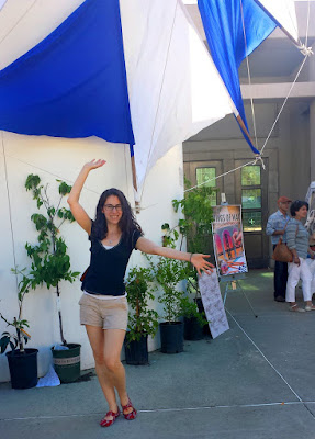
[UPDATED APR. 2025] A lot of my friends express amazement at the various festivals I take them to. How do I know about them? Some are obscure and yet absolutely incredible! Well, it has been a process of exploration over the years... All the photos here are casual snapshots or video stills taken by me. BEST FESTIVAL AWARD - The Greek Festival in the Oakland hills This festival brings out happiness, as evidenced by my friend Andrea In May . The awesome views of the Bay from the top of the Oakland hills complement the yummy food, the dance shows, arts, crafts, clothing, jewelry, history, music, architecture, participatory folk dance, etc. The event takes place on a plaza surrounding a Greek Orthodox church; some of it is outdoors, and some indoors. The admission fee is very modest ($6 , or $5 in advance.) The food tends to be a tad better on Saturday; if you go on Sunday, don't wait too late, because many food items run out....


Nice work adding all the interesting links about the things that you encounter. I personally enjoy sampling the local foods in the places I visit. Maybe you could work in a little of that into your blog as well!
ReplyDeleteThanks for the compliments and for your suggestion. I have been reflecting on your idea about covering the local food. I certainly enjoy international foods, and I'm lucky to live in the San Francisco area, where there's plenty of choice...
DeleteBut how to include that element in this blog - that's what I'm not sure about! I thought of researching the cuisine of the countries I visit in my virtual travel... maybe even try them out myself if I can find them in my area.
But then what? Do I just post a picture of the food and a caption about its name and description? I feel that people are already flooded by food pictures from their friends on their social media feeds....
If I came across someone who wanted to COLLABORATE on the cuisine element, I'd certainly consider it! Maybe someone who is a chef or serious foodie - perhaps with a food/travel blog. Someone who could find or create a rich media experience, well beyond just a "food photo". For example, video featuring that food, its creation, eating it on location, etc.