Around the World in a (Simulated) Airplane, Part 1 : Florida to Cuba (with side trip to the mountains of Iran)
 |
| See the above region on Google Maps |
Well, I just kept going from there - and decided to go around the world :)
Of course, I'll also be taking "side tours" in all sorts of other locations... Well, that's the beauty of virtual flying: just pause a journey and do a side-trip somewhere across the globe!
The flight simulator, XPlane 11, has unbelievable coverage of the entire world. I periodically compare the views against Google Earth, and I've been impressed by the accuracy of the landscapes and coastlines. Buildings and vegetation could use improvement - but not so bad as to ruin the amazing experience of traveling up-close to wherever it suits me, or my friends (nostalgic fly-overs on their hometowns has quickly become a hit with my friends!)
In this blog/virtual-travel log, I'll be posting a few screenshot and video highlights from the simulator, plus some maps/Google Earth views, as well as occasional illustrative photos/videos/music/articles.
From the Florida Keys to Cuba
 |
| Dry Tortugas National Park |
How did I get there? Taking off from Miami, I followed the scenic Overseas Highway to Key West:
 |
| The Overseas Highway (photo source) |
Did you know that they have an annual Underwater Music Festival in the Florida Keys?
 |
| Mermaid in Underwater Music Festival, Florida Keys (photo source) |
Here's Dry Tortugas National Park as seen from a real airplane. It's the most remote U.S. national park, 115 km (70 miles) west of Key West. Notice the 19th-century Fort Jefferson in the background:
 |
| Dry Tortugas National Park, with Fort Jefferson in background (image source) |
Cuba Landfall
Leaving Dry Tortugas behind, I proceed south-bound and, even though the little plane rarely exceeds 130 knots of speed (150 mph or 240 Km/h), before long I make a landfall at Bahia de Mantanzas, 55 miles east of Havana. A little resemblance to the South Bay in San Francisco: |
| Landfall in Cuba: Bahia de Mantanzas |
Notice how strikingly accurate that bay looks, when compared to the same location as seen on Google Earth!
 |
| Same Bahia de Mantanzas, as seen on Google Earth |
Havana, Cuba
Cuba is amazingly close to Florida: just 150 Km (95 miles) south of Key West. I knew that in an abstract way, but experiencing it in a (simulated) flight really makes it much more poignant!
Havana lies by a large bay that is vaguely reminiscent of the San Francisco bay.
Havana lies by a large bay that is vaguely reminiscent of the San Francisco bay.
 |
| Approaching Havana along the north coast of Cuba (flying east) |
 |
| Havana, Cuba (photo source) |
 |
| Havana, Cuba - Museum of the Revolution (source: Google maps) |
The Little Islands of Cuba's North Coast
There are a number of intriguing little islands along the north coast of Cuba, east of Havana. |
| Little islands off the north coast of Cuba |
All those little islands made for some great flying! Not surprisingly given my boating background, my first impulse with the new plane is to turn it into something of a "flying boat!" Here's a little video snippet:
 |
| The little Cessna 172, over the north coast of Cuba |
One great thing about flying in a simulator is that the flying can be done from within the cabin, as you'd expect, as well as from "outside" the plane. The latter is harder to do, but I'm beginning to get the hang of it!
I managed to find user-submitted Google Street View 360-degree shots from Cayo Cruz, which is about as far as I went before turning inland and crossing Cuba on the way to the Cayman Islands (covered in the next blog entry.)
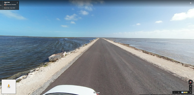 |
| Cayo Cruz, on an island off the north coast of Cuba (user-submitted Google Street View) |
Then I just drove the airplane on that road for a while, and later took off from that it - a great advantage of a small plane! (I wouldn't recommend doing that with a real airplane, lol)
AIRPORTS: Miami International, Florida, USA (KMIA) ; Marathon, Florida Keys (KMTH) ; Sugar Loaf Shores, Florida (7FA1) ; Key West, Florida (KEYW) ; Juan Gualberto Gomez, Cuba (MUVR) ; Jose Marti, Havana, Cuba (MUHA) ; Kawama, Cuba (MUKW) ; Las Brujas, Cuba (MUBR) ; Jardines Del Rey, Cuba (MUCC)
CONTINUED IN PART 2 : Cuba to Jamaica via the Cayman Islands
Listing of all episodes
"Bonus" Side Tour : crossing the Alborz Mountains of northern Iran, from Tehran to the Caspian Sea
The beauty of the virtual world: to casually take a pause from your Caribbean trip, and carry on a little "side tour" at the opposite end of the world!Two of my goals in getting the simulator were to learn how to fly (at least simulator-style) and to virtually explore all sorts of scenic locations around the world. A third purpose emerged early on: therapeutic "nostalgia" trips. For example, a friend of mine, who got asylum in the U.S. as a young adult, and unable to travel back for political reasons, wishing to see her native Tehran and the small seaside town where she used to travel with her family as a kid, on the Caspian Sea (the world's largest inland body of water, between Iran and some of the former soviet republics.)
 |
| Crossing the Alborz Mountains, north of Iran |
We took off from an airport in Tehran, and crossed over the Alborz Mountains. It was a very emotional journey for my friend, and quite a workout for the small airplane to negotiate those tall mountains! I had to re-route at times, because I lacked speed/altitude to climb over... Smoke started coming out of one engine: these simulators are really getting hyper-realistic!!
 |
| Taking off from an airport in Tehran, Iran, the Alborz mountain range looms in the distance |
 |
| Alborz Mountains, in North Iran. The Caspian Sea is visible at a distance. Notice the small lake near the center. |
 |
| Checking out that little lake up close |
 |
| Finally about to clear the mountains; the Caspian Sea can be seen at a distance |
 |
| Descending on the other side of the mountain peaks, towards the Caspian Sea |
 |
| Approaching the small town by the Caspian Sea where my friend spent her summers with her family in her youth. I landed in the airport visible on the left, by the water |
The smoke from the engine - which at one point filled the cabin! - finally subsided (glad to be flying a simulator and not a real airplane, haha), and we landed in the small Caspian Sea town of my friend's youth. Not content with that, we took off again, and landed on a city street - then drove by her mom's old house! Individual houses are not authentic, but the streets are realistic and she recognized the layout she remembered from her youth...
For anyone imagining Iran as a flat desert, the flight over the Alborz Mountains is a definite eye opener: at least twenty peaks higher than 4,400 m (14,400 ft). I came across a fascinating 360-degree video about crossing the Alborz Mountains on a train :
[Maximize and then click-drag the mouse to point your view. On a mobile, it seems to require the YouTube app]
CONTINUED IN PART 2 : Cuba to Jamaica via the Cayman Islands
Listing of all episodes


Comments
Post a Comment